8 Epic Hikes You Can’t Miss in Ushuaia, Argentina
Ushuaia is often labeled as the end of the world, and to be honest, I was expecting a tacky tourist town where people go as a landmark to finish their adventure, but it’s much more than that. The true magic lies in its hiking trails. From verdant valleys to glacial lagoons and panoramic mountain ridges, the hikes around Ushuaia are world-class and accessible. If you love nature and unexpected terrain, this place will surprise you.
When to Visit Ushuaia
The best time to visit Ushuaia for hiking is from October–April. Summer (December to February) is the most popular season, with long daylight hours, mild temperatures, and perfect conditions for hiking, boating, and exploring Tierra del Fuego National Park. Trails are clear, and the landscapes are vibrant with greenery, lakes, and snow-dusted peaks. It’s also the only time with departures to Antarctica. However, everything is more crowded and more expensive.
The best time is the shoulder seasons like October–November and March–April, which offer fewer crowds and still some great weather, though it’s possible certain trails and services may be limited. Winter (June to August) has very limited hiking options, but turns Ushuaia into a snowy wonderland ideal for skiing and snowboarding, especially at Cerro Castor.
Want to be protected from accidents around the world, wherever you go?

How to Get to Ushuaia
Ushuaia is located on the island of Tierra del Fuego, which is split between Chile and Argentina, and can be accessed by ferry. An airport serves it with flights from Buenos Aires, Córdoba, and other places in Argentina. Overland travel is possible, but nowhere is very close, and long bus rides from mainland Argentina or Chile are expensive. Some arrive by rental car, cycling, or even hitchhiking, like I did. This part of Argentina is not connected to the rest of the country, so you can only reach it by crossing through Chile.
Want to take out the stress of getting a SIM Card in another country and be connected as soon as you step in?

Where to Stay in Ushuaia
The town is relatively small but offers a range of accommodation, including hostels, mid-range hotels, and guesthouses. Remember to book ahead in the peak summer months.
Need a Place to Stay? Here’s some of my favourite places to stay in Ushuaia
$$$ Los Cauquenes Resort + Spa + Experiences – Click here for rates and availabilty
$$ La Vela – Click here for rates and availabilty
$ Hostel Los Cormarones – Click here for rates and availabilty
1. Laguna 5 Hermanos
This well-marked moderate hike leads to a hidden high-altitude lagoon framed by five rocky peaks, the Cinco Hermanos (Five Brothers), as well as Monte Olivia. It’s an 8.7km out-and-back with 850m of elevation gain. It’s labeled as Hard on AllTrails, but I really didn’t find it too challenging. The trail climbs steadily through the forest before opening onto the rockier plateau. Expect muddy sections and exposed rock scrambling near the end of the trail. Perfect for a day hike close to town. I saw no one else while doing this hike. It’s a bit out of town, so there’s no public transport there, but hitchhiking was easy.


My favourite app to discover, plan, and track my hikes is AllTrails.
You can search over 450k trails 80M members, and it’s free to join.
2. Cerro Guanaco Summit Trail
This is the only trail on the list that is inside the National Park, meaning you have to pay to enter. It’s another out-and-back, 13.7km with just over 1000m of elevation gain. To access this trail, you must pay a fee at the park entrance. Then, get off at the third bus stop at the visitor’s center, where you must fill out a registration form with your passport number to climb the mountain.

Climb up to Cerro Guanaco’s summit for superb bird’s-eye views of Ushuaia and the surrounding mountains. The trail gains altitude quickly through forest and rocky sections. It’s a good trail; however, I’d recommend getting to all the free ones first, which are just as good, if not better.
3. Laguna del Caminante & Cueva de Jimbo
This is by far my favourite hike in Ushuaia, and one of my favourite day hikes I’ve done in the world. It’s not difficult technically, but it’s quite a long horseshoe at 24km and 1100m of elevation gain. I took two Danes with me on their first hike ever, and not only did they smash it, but they also loved it. It’s a bit hard to find the start of the trail, but just follow directions to here on Google Maps.
This trail climbs through a forest and follows a massive valley (Cañadón de la Oveja). When we visited in March, it had just snowed the night before, so we were the trailblazers that day, just following the map and a cute dog we had met along the way.


There is about a 1km detour to the infamous Cueva de Jimbo, but this section is not on the regular AllTrails route. This cave has had some deaths in recent years and is sometimes closed off to tourists, so best to ask before going. Some people head to the cave as their destination, then turn around. But I highly recommend continuing over the mountain pass. The day we visited, there was an extreme windstorm at the top, which almost caused us to turn around.
On the other side, there is another side trail that heads to the main lookout – Laguna del Caminante. This stunning lagoon is one of the best views Patagonia has to offer, and that’s a big claim. There is a campsite here for those planning on making this trek in two days. The back side of the trail is not too exciting, mostly flat terrain through forest, and many river crossings. The trail ends at the same spot as the trailhead for the Laguna de los Témpanos Trail.
4. Laguna Esmeralda
This is by far the most popular trail in Ushuaia, and is always quite crowded. Starting from a peat bog valley, the trail climbs toward Laguna Esmeralda, known for its emerald green waters. Up until this part, there are boardwalks and lots of people. The trail is 8.7km with 250m of elevation gain; it’s marked as Moderate on AllTrails, but it’s a pretty easy trail. Due to its popularity, it’s possible to visit with a guide if you prefer.


4.5 Ojo del Albino
If you’re up for an adventure, you can continue further uphill to reach the Ojo del Albino glacier lagoon on Cerro Bonete. You will pass a sign that says that a guide is mandatory, though no one is there to check. Continue at your own risk. The path beyond Esmeralda is often rocky, unsigned, and best done with a local guide for safety and navigation. This was by far the most technically difficult trail that I did in Ushuaia. It’s an extra 6.6km with 570m of elevation gain. Since you have to get to Laguna Esmeralda first, the total trek is 15.3km and 790m of elevation gain.


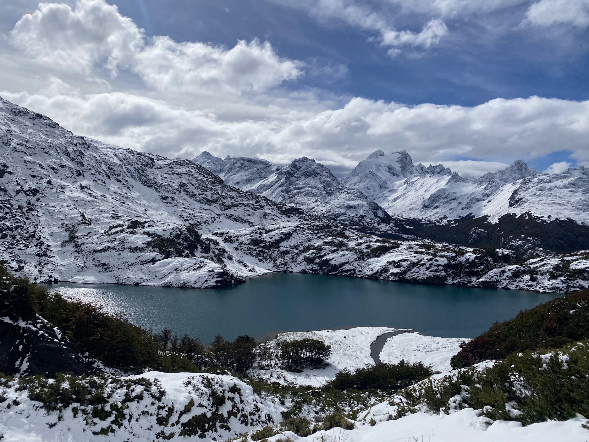
5. Laguna Turquesa
The shortest trail on this list is Laguna Turquesa. Just across the road from Laguna Esmeralda. If you’re not trekking all the way to Ojo el Albino, you could even combine it into the same day. It’s only 3.5km return and 350m of elevation gain. This moderate path leads to a pristine lagoon with intense turquoise color, nestled in a glacial valley. The landscape includes mossy bogs, lenga trees, and snowfields above, especially in late spring and early summer.
6. Glaciar Vinciguerra (Laguna de los Témpanos Trail)
This scenic route climbs into the Alvear mountain chain, passing iceberg-strewn lakes that form from the Vinciguerra glacier meltwater. This hike is great because you can take public transport to get near the start. Expect elevation gain and changing terrain. Carry enough water and gear for shifting weather all year round. This out-and-back trek will take you 11.6km and up 660m. It starts out quite flat through some farmland, where you will pass by horses, and ends at the glacier at the top. There are some unofficial trails to go up close or even stand on the glacier itself, but this can be quite dangerous. This is another trail that is possible to hike with a guide.


7. Glaciar Martial
The closest hike to town is the Cerro Martial. It’s probably not the most exciting if you have done other hikes around town, but it’s different because you get to stand on a glacier as you look out towards the end of the world. It’s a bit more commercial than some of the other trails; it even has a cafe at the bottom.
The official path is relatively short but steep – 6.4km out and back with 500m of elevation gain, leading to expansive views over Ushuaia, the Beagle Channel, and distant snow-capped peaks. However, if you don’t want to pay for transport, you can start at the very bottom like I did, but it adds about 5km each way. Since you are just going up a road, it’s also possible to hitchhike. I did find people to share a taxi with on the way down, though!


8. Cerro del Medio (Mirador Trail)
Just on the other end of town from where you start the Glaciar Martial hike, you can start the hike up to Cerro del Medio. It’s another moderate ascent of 850m through 11.1km, but this is one of the few trails that doesn’t end up at a lagoon or a glacier. This trail offers views toward the Beagle Channel and Ushuaia, though it’s honestly not as impressive as most of the other trails on this list.
It’s often bundled with a longer hike up to Cerro Abismo, which is what would make this trek worth it. Expect some scrambling near the summit. There is also a trail that goes down the mountain just on the other side of the lookout, which means you can turn the hike into a horseshoe instead of going back the same way, which I always prefer.
Final Thoughts on Ushuaia Hiking
Ushuaia is daring and breathtaking in every direction. These hikes take you from glacial lagoons to volcanic ridges and hidden valleys. Some “technically” require guides, others you can do solo. If you want GPS tracks, reviews, or printable maps, explore each trail on AllTrails. Lace up your boots and get ready, the end of the world is just the beginning.